- What is a GPS?
- How does it work?
- How many Satellites orbit the earth at any given time?
- What disciplines utilize GPSs?
- History of GPS
Lecture 6: GPS
GIS & Remote Sensing
J Mwaura
Lecture Outcomes
GPS
Global Positioning Systemis a radio navigation system developed by the US Department of Defense
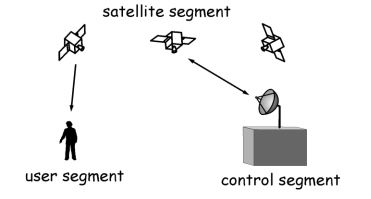
The entire system comprises of three parts;
- The space segment
- The control segment
- The user segment
Space Segment
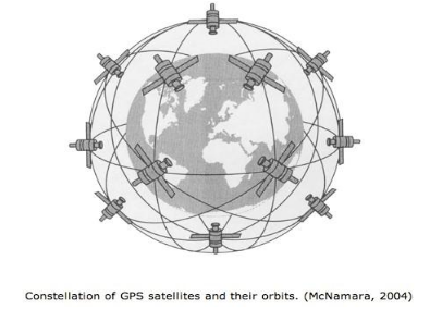
A constellation of 24-32 satellites are in geosynchronous orbit around the earth, at least 24 are operational at any time
All transmit a one way signal enabling users to locate their position on earth
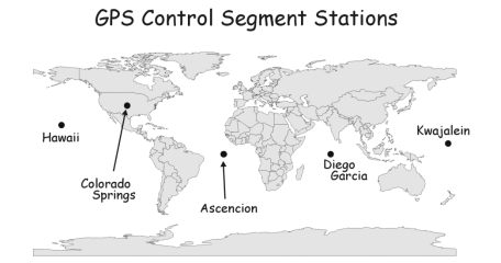
Control Segment
The US Department of Defense uses 5 ground control stations to send corrections to the satellites where necessary
Satellites pass over these stations once every 12 hours where they receive corrections
The ground control stations time is always correct. - This is critical because all calculations originate from the satellites and time is a critical part of the process
User Segment
The satellites constantly give a three dimensional positioning that anyone with the appropriate equipment has access to.

GPS Positioning
Your position on earth is determined by measuring your distance from the group of satellites
The GPS receiver measures the time it takes for a radio signal to reach to it from the satellites, this depends on an accurate clock
The time is then converted to a distance and through triangulation, your position is calculated. Once there is time and velocity, distance can be calculated
GPS Positioning
The GPS receiver needs at least 3-4 signals from satellites to derive a position
There are always 4 satellites overhead at any one time. The satellites require a line of sight with the receivers to pinpoint location; this is why you generally don't get good signal indoors or under thick canopies
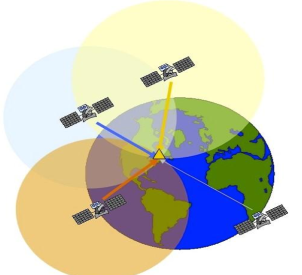
All satellites have the same time and they always know exact position
GPS Errors
- Number of satellites in the sky and the arrangement of them
- Multi-path Errors - this occurs when radio signals bounce off terrestrial objects such as buildings or natural phenomenon, for example mountains, before reaching the receiver
- Atmospheric interference
- Satellite drift - Occasionally the satellites drift slightly off course. The satellites have 4 very precise atomic clocks and a microprocessor for limited data analysis of self monitoring. The ground control stations play an important part here by sending corrections to the satellites where necessary as they pass over the ground control stations
- Receiver clock errors - A receiver's built-in clock is not as accurate as the atomic clocks onboard the GPS satellites. Therefore, it may have very slight timing errors
Wrap up
- Satellites are 12600 miles above the earth
- Moving at 8653 miles per hour
- They circulate the earth once every 12 hours
End of Lecture
GIS & Remote Sensing
That's it!
Queries about this Lesson, please send them to:
*References*
- Geographic Information System Basics, 2012
J.E.Campbell & M. Shin- Fundamentals of GIS, 2017
Girmay Kindaya- GIS Applications for Water, Wastewater, and Stormwater Systems, 2005
U.M. Shamsi- Analytical and Computer Cartography, 2nd ed.
Keith C. Claike- Geographic Information Systems: The Microcomputer and Modern Cartography, 1st ed.
Fraser Taylor- Land_Surveyor_Reference_Manual, 2nd ed.
Andrew_L._Harbin
Courtesy of Open School