- Location Based Services
- What is a GPS?
- How does it work?
- How many Satellites orbit the earth at any given time?
- Coordinates Systems
- Map projections
Lecture 6: GPS, Coordinates Systems & Map projections
Geographic Information Systems
J Mwaura
Lecture Outcomes
Location Based Services
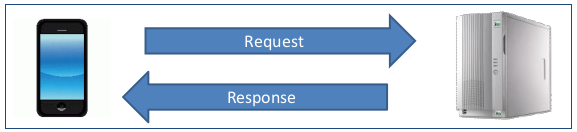
Positioning
Location Based Services
Location Based Services (LBS) are services,
- That are accessible with mobile devices through a mobile network
- Integrating a mobile device's location with other information so as to provide added value to the user
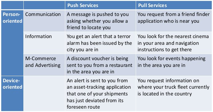
Classification of LBS applications
- Person-oriented - Person located can control the service
- Device-oriented - Person or object located is not controlling the service
Location Based Services
Types of application design
- Pull Services
- Push Services

Location Based Services
Application examples
Location Based Services
Application areas
- Travel services
- Routing, city, hotel and restaurant guides
- Emergency
- Locating a person in need, warn persons in danger
- Fleet management
- Phone tracker
- Child watch, anti-theft tracking
- Friend finder, blind dating
- Mobile phone tariffs
Positioning
Self-locating: User (his mobile device) locates himself
- Global Positioning System (GPS, GLONASS, Galileo)
- Manual position input (not smart)
External locating: Operator locates the user's mobile device
- Determining the current mobile network cell
- Signal comparison between three adjacent cells
Locating provided by third parties
- Location transponder
- Peer-to-Peer locating
Positioning
Global Positioning System (GPS)
- Enables three dimensional positioning near the earth
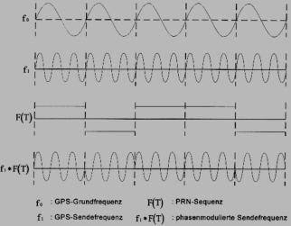
- Measuring the runtime of signals between the satellite and the GPS-receiver, from which the distance and the position can be deduced (trilateration)
- The transmitted signal describes a circular sphere centered at the satellite on which surface the signal is received at the same time -> circular baseline of equal receiving times on earth
What is GPS?
GPS
Global Positioning Systemis a radio navigation system developed by the US Department of Defense
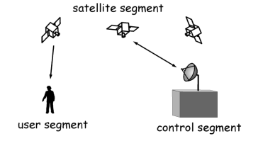
Three major segments:
- The space segment
- The control segment
- The user segment
Space Segment
A constellation of 24-32 satellites are in geosynchronous orbit around the earth, at least 24 are operational at any time
All transmit a one way signal enabling users to locate their position on earth
Six orbits
- 55° inclination each
- 20200 km altitude
- 11h 55min orbital period
From every point at earth at least 5 satellites are always visible
5 different types of satellites: Block I, Block II, Block IIA, Block IIR, and Block IIF

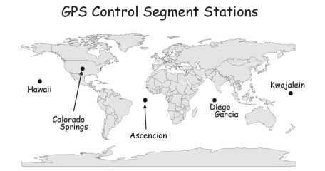
Control Segment
Almost passive ground stations to track the flight paths of the satellites
- 4 monitoring stations operated by the U.S. air force
- Since 2006 - 6 more stations operated by the NGA (National Geospatial-Intelligence Agency)
- One Master Control Station for evaluation
Every satellite can always be received by at least two ground stations
Satellites pass over these stations once every 12 hours where they receive corrections. The ground control stations time is always correct
User Segment
The satellites constantly give a 3D positioning to GPS-receiver
User Segment
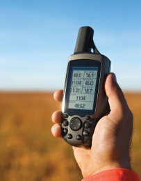
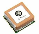
GPS-receiver
- Composed of an antenna, receiver-processors, and a highly-stable clock
- May also include a display for providing location and speed information
- Dedicated devices or integrated into cars, mobile phones, watches, etc

GPS Positioning
Your position on earth is determined by measuring your distance from the group of satellites
The GPS receiver measures the time it takes for a radio signal to reach to it from the satellites, this depends on an accurate clock
The time is then converted to a distance and through triangulation, your position is calculated. Once there is time and velocity, distance can be calculated
GPS Positioning
The GPS receiver needs at least 3-4 signals from satellites to derive a position
There are always 4 satellites overhead at any one time. The satellites require a line of sight with the receivers to pinpoint location; this is why you generally don't get good signal indoors or under thick canopies

All satellites have the same time and they always know exact position
GPS - Message format
Every 6 seconds
- Week and time within the week
- Position
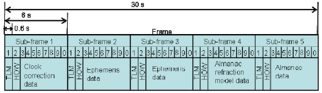
GPS - Message format
Health of the satellite
Ephemeris
- In a spherical polar coordinate system
- Updated every 2h
Almanac
- Coarse orbit and status information for all satellites
- Data related to error correction
- Updated every 24h
GPS Errors
- Number of satellites in the sky and the arrangement of them
- Multi-path Errors - this occurs when radio signals bounce off terrestrial objects such as buildings or natural phenomenon, for example mountains, before reaching the receiver
- Atmospheric interference
- Satellite drift - Occasionally the satellites drift slightly off course. The satellites have 4 very precise atomic clocks and a microprocessor for limited data analysis of self monitoring. The ground control stations play an important part here by sending corrections to the satellites where necessary as they pass over the ground control stations
- Receiver clock errors - A receiver's built-in clock is not as accurate as the atomic clocks onboard the GPS satellites. Therefore, it may have very slight timing errors
Random & Clock errors


Coordinates Systems
Mapping of Spatial Data
Challenges
- Projection of the 3D surface on 2D (paper, film, screen)
- Selection of the spatial objects and their attributes to be displayed
- Generalization of geometric and thematic properties (simplify, omit depending on scale)
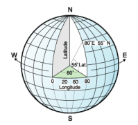
Coordinates Systems
Graticule
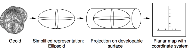
Geoid -> ellipsoid -> (sphere) -> latitude/longitude
Mapping the earth (sphere, ellipsoid) to a plane
Two tasks
- Conversion of geographic coordinates (longitude and latitude) to cartesian coordinates (x,y; easting,northing)
- Scaling of the map
Map Projections
Desired properties
- Length preservation
- Equivalent (equal area) - preserve area measurements shape, angle, & scale may be strongly distorted
- Conformal: important for navigation in shipping and air transport
- Areas and angles cannot be preserved at the same time, therefore - Compromise projections minimize overall distortion

Projected Coordinates Systems
Refers to cartesian coordinate systems based on projections
Geoid -> ellipsoid -> developable surface -> plane -> x,y
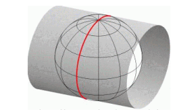
Developable surfaces: conic, cylindrical, azimuthal (plane)
Distortion: conformal, equidistant, equal area
Developable Surfaces

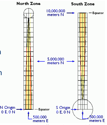
UTM Coordinate System
Divides the surface of the earth into 6° zones
Covers the area between 84° North and 80° South

UTM Coordinate System
The diameter of the transverse cylinder is slightly smaller than the diameter of the Earth -> secant projection with two lines of true scale (about 180 km on each side of the central meridian)
Coordinate systems in GIS
Representation of coordinate systems in GIS
- Metadata file
- ESRI PRJ file
- EPSG codes provided by OGP - Int. Org. of Oil and Gas Producers Surveying and Positioning Committee, formerly EPSG - European petroleum survey group
Vertical datum support often missing in GIS - specialized tools
Coordinate systems in GIS
Coordinate system definitions

End of Lecture
Geographic Information Systems
That's it!
Queries about this Lesson, please send them to:
*References*
- Geographic Information System Basics, 2012
J.E.Campbell & M. Shin- Fundamentals of GIS, 2017
Girmay Kindaya- GIS Applications for Water, Wastewater, and Stormwater Systems, 2005
U.M. Shamsi- Analytical and Computer Cartography, 2nd ed.
Keith C. Claike- Geographic Information Systems: The Microcomputer and Modern Cartography, 1st ed.
Fraser Taylor- Land_Surveyor_Reference_Manual, 2nd ed.
Andrew_L._Harbin
Courtesy of Open School