Lecture 2: Basics of Remote Sensing

Geographic Information Systems

J Mwaura

What is Remote Sensing?

Remote Sensing

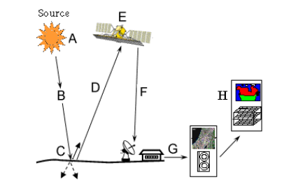
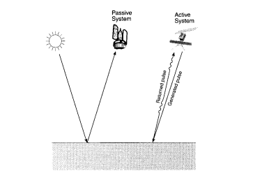
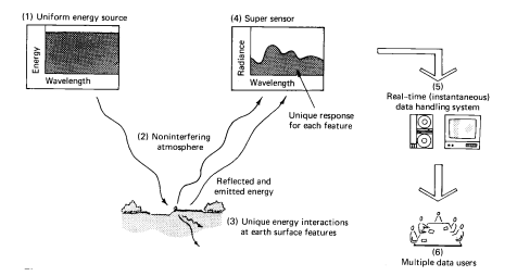
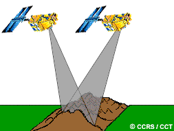
The art & science of obtaining information about an object or feature without physically coming in contact with that object or feature

Remote sensing occurs by sensing & recording reflected or emitted energy and processing, analyzing, and applying that information

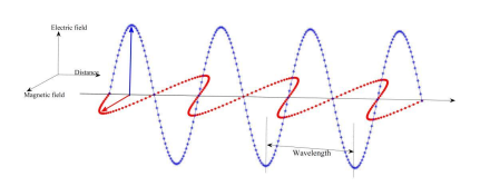
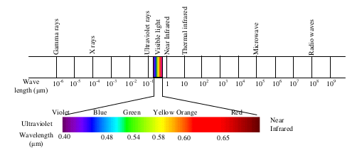
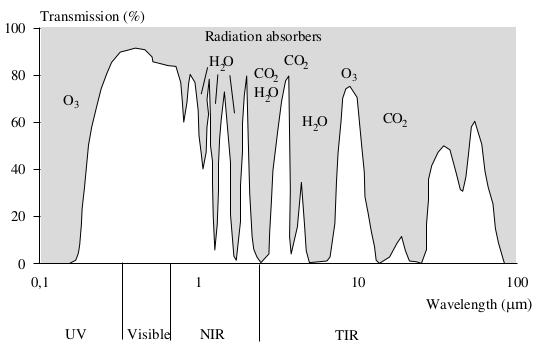
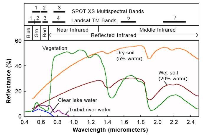
In our case, remote sensing is the process of inferring surface parameters from measurements of the electromagnetic radiation (EMR) from the Earth's surface

Forms of Remote Sensing

Variations in acoustic wave distributions (e.g., sonar)

Variations in force distributions (e.g., gravity meter)

Variations in electromagnetic energy distributions (e.g., eye, satellite)

Electromagnetic Energy

Electromagnetic energy or electromagnetic radiation (EMR) is the energy propagated in the form of an advancing interaction between electric & magnetic fields (Sabbins, 1978)

EMR spectrum is the distribution of the continuum of energy can be plotted as a function of wavelength (or frequency)

components

Electromagnetic Energy

components

All matters reflect, emit or radiate a range of electromagnetic energy, depending upon the material characteristics

In remote sensing, it is the measurement of electromagnetic radiation reflected or emitted from an object, is the used to identify the target and to infer its properties

Radiation in the Atmosphere

Atmosphere influences the incoming radiation in two ways;

  1. Atmospheric scattering - small particles in the atmosphere diffuse a portion of the incident radiation in all directions
    1. Rayleigh scattering
    2. Mie scattering
    3. Non-selective scattering
  2. Atmospheric absorption - incident energy is retained by particles

Atmospheric Windows

Refers to wavelength bands where the atmosphere transmits radiation

Most remote sensing systems sense radiation in the visual and NIR band because of the high transmission of radiation

The Ultraviolet (UV)-band is subject to heavy scattering, and absorption by ozone

components

Energy Interactions

Incident electromagnetic energy may interact with the earth surface features in three possible ways:

  1. Reflection
  2. Absorption
  3. Transmission

These interactions depends on;

  1. Wavelength of the radiation
  2. Angle at which the radiation intersects the surface
  3. Composition and physical properties of the surface

Reflection from the Earth's Surface

The reflectance characteristics of the surface features are represented using these curves

components

Spectral reflectance curve refer to graphical representation of the spectral response of an object over different wavelengths of the electromagnetic spectrum

Vegetation reflectance curve

et
Vegetation interaction with EM radiation

Stages in Remote Sensing

components

A. Emission of electromagnetic radiation

  • The Sun or an EMR source located on the platform

B. Transmission of energy from the source to the object

  • Absorption and scattering of the EMR while transmission

Stages in Remote Sensing

components

C. Interaction of EMR with the object and subsequent reflection and emission

D. Transmission of energy from the object to the sensor

E. Recording of energy by the sensor

  • Photographic or non-photographic sensors

Stages in Remote Sensing

components

F. Transmission of the recorded information to the ground station

G. Processing of the data into digital or hard copy image

H. Analysis of data

Remote Sensing Systems

components

Passive

  1. Source of energy is that naturally available such as the Sun
  2. Solar energy reflected by the targets at specific wavelength bands are recorded using sensors on board air-borne or space borne platforms

Passive & Active Remote Sensing

components

Active

  1. Own source of energy
  2. Sensors, emit radiation on the study object and measure the reflected amount of radiation

Remote Sensing Platforms

Remote sensing platforms can be classified as follows, based on the elevation from the Earth's surface at which these platforms are placed

  • Ground level remote sensing
    • Ground level remote sensors are very close to the ground
    • They are basically used to develop and calibrate sensors for different features on the Earth's surface
    • Examples: hand held cameras, scanners, cranes, ground vehicles, tethered balloons, and even towers

Remote Sensing Platforms

  • Aerial remote sensing
    • Low altitude aerial remote sensing
      • Examples; airplanes, helicopters, unmanned aerial systems (UAS) & free-floating balloons
    • High altitude aerial remote sensing
      • Examples; high-altitude aircraft

Remote Sensing Platforms

Spaceborne remote sensing e.g. Polar orbiting, Sun-Synchronous orbiting, Geo-stationary satellites

Spaceborne
Spaceborne platforms orbiting Earth. Source: Pixalytics

Spaceborne Remote Sensing Platforms

Polar Orbit (or near-polar orbit)

Spaceborne

Polar orbit is an orbit with an inclination angle between 80 & 100 degrees

These satellites are typically placed in orbit at 600 km to 1000 km altitude

Uses - measuring ozone concentrations in the stratosphere or measuring temperatures in the atmosphere

They provide global coverage with higher spatial resolution, but they cannot provide continuous viewing of one location

Examples; Landsat, NOAA, SPOT, ERS etc

Spaceborne Remote Sensing Platforms

Sun-synchronous Orbiting satellite passes over any given point on Earth's surface at the same local solar time

Spaceborne
Diagram show the orientation of a Sun-synchronous orbit (green) at four points in the year. A non-Sun-synchronous orbit (magenta) is shown for reference. Source: Wikipedia

Sun-synchronous Orbiting

Altitudes of Sun-synchronous orbits are typically around 700 km to 850 km, with orbital periods between 90 to 100 minutes (or, about 14 orbits per day)

These satellites ensures consistent illumination conditions when acquiring images in a specific season over successive years, or over a particular area over a series of days

This is an important factor for monitoring changes, as they do not have to be corrected for different illumination conditions

Use - change detection monitoring

Examples; Landsat, SPOT, Sentinel, POES, Quickbird, IKONOS, Beijing-1, Terra, Aqua, Aura, Skysat etc

Spaceborne Remote Sensing Platforms

Geostationary Orbit/Geosynchronous orbits

Spaceborne
Geostationary versus polar orbiters. Source: David Babb

Geostationary orbits are located at a distance of 36,000 km above the Equator (inclination angle of 0 degrees)

They are positioned at different longitudes in order to increase global coverage

Geostationary Orbit/Geosynchronous orbits

Orbital period of these satellites is equal to the rotational period of the Earth - meaning the satellite is at a fixed position relative to the Earth

They can make repeated observations over a given area, with high temporal resolution, but lower spatial resolution

Uses - monitoring severe weather environments in real time

Examples; GEOS of USA, Meteostat of Europe, INSAT of India, Himawari of Japan, Fengyun of China etc

Spaceborne
NASA's Earth Observing Satellites (EOS) and their Mission Descriptions
rss
Components of an Ideal Remote Sensing System
et
Characteristics of Real Remote Sensing Systems

Characteristics of Images

Electromagnetic energy may be detected either photographically or electronically

An image refers to any pictorial representation, regardless of what wavelengths or remote sensing device has been used to detect and record the electromagnetic energy

A photograph refers specifically to images that have been detected as well as recorded on photographic film

A photograph represented in a digital format or a digital image consist of picture elements or pixels

Characteristics of Images

rss

Pixels represent the brightness of each area with a numeric value or digital number

Band refer to information from a narrow wavelength range is gathered and stored in a channel

Bands are combined and displayed digitally using the three primary colours (blue, green, & red)

Remote Sensing Data

The quality of remote sensing data consists of its spatial, spectral, radiometric and temporal resolutions

Resolution is the minimum distance between two objects that can be distinguished in the image

In remote sensing, resolution is used to represent the resolving power, which is the capability to identify the presence of two objects, as well as their properties

  1. Spatial - X & Y dimensions
  2. Spectral - number of bands
  3. Radiometric - number of bits or bytes per sample
  4. Temporal - number of samples per time unit

Spatial Resolution

Refer to the size of a pixel that is recorded in a raster image

Pixel size may correspond to square areas ranging inside length from 1 to 1,000 meters

A measure of size of pixel is given by the Instantaneous Field of View (IFOV)

spatial
spatial
Schematic representation of feature identification at different spatial resolutions

Spectral Resolution

Refer to the ability of a sensor to define fine wavelength intervals or the ability of a sensor to resolve the energy received in a spectral bandwidth to characterize different constituents of earth surface

Many remote sensing systems are multi-spectral, that record energy over separate wavelength ranges at various spectral resolutions

spectral
Hypothetical representation of remote sensing systems with different spectral resolution (Source: Gibson, 2000)

Radiometric Resolution

Refer to the ability of the sensor to distinguish different grey-scale values

It is measured in bit. The more bit an image has, the more grey-scale values can be stored, and, thus, more differences in the reflection on the land surfaces can be spotted

Ranges from 8 to 14 bits, corresponding to 256 levels of the gray scale and up to 16,384 intensities or shades of color, in each band

rss
radiometric
The higher the bit, the more grey-scale values can be differentiated by a sensor

2 to the power of bit = number of grey-scale values

Temporal Resolution

Refer to the frequency of flyovers by the satellite or plane

Temporal
Temporal
Same location, different dates

Image Distortions

  • Geometric errors - resolved by geo-referencing & warping
  • Radiometric errors and distortions - uneven illumination of objects
  • Topographic/Terrain errors - uneven illumination due to terrain
  • Atmospheric errors - effects of atmospheric haze

Digital Data Processing

Manual interpretation


Digital analysis

Remote Sensing Applications

Remote sensing provides a means of observing large areas at finer spatial & temporal frequencies

Areas of applications;

  • Watershed studies
  • Hydrological states & fluxes simulation
  • Hydrological modeling
  • Disaster management services such as flood and drought warning and monitoring
  • Damage assessment in case of natural calamities
  • Environmental monitoring
  • Urban planning

Advantages of Remote Sensing

  1. Provides data of large areas
  2. Provides data of very remote and inaccessible regions
  3. Able to obtain imagery of any area over a continuous period of time through which the any anthropogenic or natural changes in the landscape can be analyzed
  4. Relatively inexpensive when compared to employing a team of surveyors
  5. Easy and rapid collection of data
  6. Rapid production of maps for interpretation

Disadvantages of Remote Sensing

  1. The interpretation of imagery requires a certain skill level
  2. Needs cross verification with ground (field) survey data
  3. Data from multiple sources may create confusion
  4. Objects can be misclassified or confused
  5. Distortions may occur in an image due to the relative motion of sensor and source

End of Session

Geographic Information Systems

That's it!

Queries about this Session, please send them to: jmwaura@jkuat.ac.ke

*References*

  • Geographic Information System Basics, 2012 J.E.Campbell & M. Shin
  • Fundamentals of GIS, 2017 Girmay Kindaya
  • GIS Applications for Water, Wastewater, and Stormwater Systems, 2005 U.M. Shamsi
  • Analytical and Computer Cartography, 2nd ed. Keith C. Claike
  • Geographic Information Systems: The Microcomputer and Modern Cartography, 1st ed. Fraser Taylor
Courtesy of Open School