Lecture 7: Spatial Data Standards and Metadata

Spatial Database Systems

J Mwaura

Spatial Data Standards

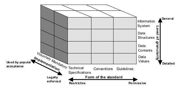
A document or collection of documents that establishes a common language, terminology, accepted practices and levels of performance, as well as technical requirements and specifications, that are used consistently for the development and use of products, services and systems in the context of spatial data

Standards commonly provide a shared understanding for processes, products, and/or services

Categories of Standards

Three primary categories (types or classes), each with subcategories (sub-types or sub-classes):

  • Forms of standard - technical specifications (restrictive), conventions, guidelines (permissive)
  • Implementation - voluntary (used by popular), mandatory (legally enforced)
  • Level of granularity - information system (general), data structures, data contents, data values (detailed)

Categories of Standards - 3D matrix

Forms of Standards

Technical specifications - most rigid and exactly of all standards, will yield consistent and identical results

Conventions/rules/protocols - are more flexible and more accommodating of variations in implementation, and therefore will yield similar but not necessarily identical results

Guidelines - most flexible type of standard and they provide a broad set of criteria against which the quality and performance of products, services, or systems can be assessed

Implementation Approaches to Standards

Mandatory - standards implemented through government legislation and regulations

Voluntary - standards implemented through consensus and popular acceptance by user community

Level of Granularity

Information system standards - apply generally and broadly to depict the overall architecture of the system

Data structure standards - organize the way in which data are logically and physically represented

Data content standards - provide rules for representing each element defined in the data structure covering, e.g., formats for dates, times, quantities and addresses

Data value standards - object or feature catalogs, providing lists or tables of terms, names, classification codes and other types of permissible values that are allowed for a particular element defined in a data content standard

Classification of Standards

Open standards - standards developed using the principles of open standards. Voluntary participation in development, the use of consensus in the review and standards review process, e.g., W3C community

Public domain standards - maintained by an organization for the general good, e.g. ISO 19115 content metdata and OGC standards

Proprietary standards - developed by organizations for internal use for products or services, e.g. Esri shapefile or Autodesk DXF has become a public domain standard

Mandatory standard; De jure standards - by law or policy and strictly enforced; De facto standards - by popular acceptance

Classification of Standards

OGC Spatial Data Standards

Spatial data services and application

  • Catalog interface, coordinate transformation, filter encoding

Spatial data encoding

  • Geography markup language (GML), a geospatial XML

Application programmer interfaces

  • Simple feature/SQL

OGC Spatial Data Standards

Internet mapping

  • Stylized layer description
  • Web feature service
  • Web map context
  • Web coverage service
  • Web map service

Components of Spatial Data Standards

A spatial database model - provides a specific abstract view of the real world represented by a database

An object or feature catalogue - contains lists of tables and lists of terms, names, classification codes that describes objects

A set of encoding specifications - governs the digitising of spatial data for storage and sharing

One or more reference or framework data sets - outline other layers or themes of spatial data for geo-referencing and integration

Importance of Spatial Data Standards

  1. Quality assurance and control
  2. Accountability in spatial design and implementation
  3. Accessibility and interoperability
  4. Best practice in spatial data management
  5. Equal opportunity for all spatial data suppliers and users
  6. Technological innovations
  7. Synergy and scale of economies in the use of spatial data

Spatial Metadata Standards

Metadata - information that describes data to clarify content, for example

  • source of the data including who and where it was produced
  • when the data were produced
  • why the data were produced
  • how data can be obtained

What if metadata are not available?

  • Look for data dictionary at least
  • Contact persons in charge

Spatial Metadata Importance

  1. Uniformity of data collection - comprehensive and structured list of definitions
  2. Data management - provide overview insights about the value of data assets
  3. Data use - how are data fit for what use (fitness for use)
  4. Data understanding - provide various insights about the data as data volume grows
  5. Data sharing - easy way to transmit meaning from one unit/organization to another
  6. Data archiving and warehousing - provide insights about how data can be combined

Examples of Spatial Data Standards

Spatial Data Standards in Canada

Examples of Spatial Data Standards

Spatial Data Standards in the United States

Examples of Spatial Data Standards

Spatial Data Standards in the European Union - INSPIRE

End of Lecture 7

Spatial Database Systems

That's it!

Queries about this Lesson, please send them to: jmwaura@jkuat.ac.ke

*References*

  • Database Systems: Design, Implementation, and Project Management, Springer. Albert K W Yeung & G. Brent Hall
  • Database Systems: Design, Implementation, and Management, 12th ed. Carlos Coronel & Steven Morris
  • Database Modeling and Design; Logical Design, 5th ed. Taby Teorey et.al
  • Fundamentals of database systems, 6th ed. Ramez Elmasri & Shamkant B. Navathe
Courtesy of