The factor by which phenomena on the surface of the earth are reduced in order to be shown on a map
Methods of repesenting scale;
Statement of scale e.g. 1 cm represents 10 kmRepresentative fraction (R.F) e.g. 1:50000Graphical or bar scale
The factor by which phenomena on the surface of the earth are reduced in order to be shown on a map
Methods of repesenting scale;
Statement of scale e.g. 1 cm represents 10 kmRepresentative fraction (R.F) e.g. 1:50000Graphical or bar scaleIt's frameworks used to determine position on the surface of the earth
For example, Geographic coordinate system (GCS);
A 3D coordinate system commonly used to define locations on the earth's surfaceLatitude is measured relative to the equator at 0 degree, with maxima of either 90 degrees north at the North Pole or 90 degrees south at the South PoleLongitude is measured relative to the prime meridian at 0 degree, with maxima of 180 degrees west or 180 degrees eastA mathematical expression used to transform locations from a 3D, spherical coordinate system to a 2D planar system
Map projection is done at a chosen scale
Why do we need map projection (problems with globes)?
Globe isn't very portableGlobe small scale makes them of limited practical use (i.e., geographic detail is sacrificed)The 3 surfaces used for map projections: Cone, Cylinder, & Plane.
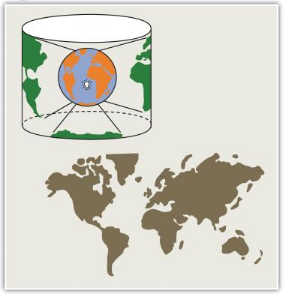
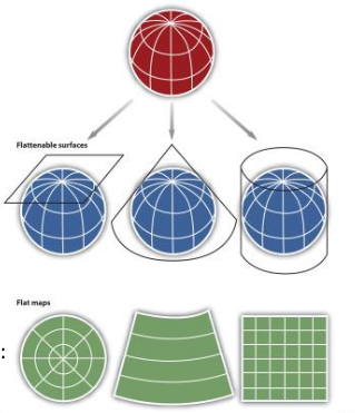
Transforming from 3D surface of the earth to a 2D plane, distortions are not only introduced but also inevitable
Distortions
distance, direction, & areaMap projections
EquidistantConformalEqual area or equivalentPreserve the quality of area
Used when accurate measures or comparisons of geographical distributions are necessary (e.g., deforestation, wetlands)
In an effort to maintain true proportions in the surface of the earth, features sometimes become compressed or stretched depending on the orientation of the projection
Moreover, such projections distort distances as well as angular relationships
Represent angles correctly between locations, also referred to as bearings
Used for navigational purposes due to the importance of maintaining a bearing or heading when traveling great distances
The cost of preserving bearings is that areas tend to be quite distorted in conformal map projectionsThough shapes are more or less preserved over small areas, at small scales areas become wildly distortedThe Mercator projection is an example of a conformal projection and is famous for distorting Greenland
Accurately represent distances
Note that distances are only correct in one direction, usually running north-south, and are not correct everywhere across the mapUsed for small-scale maps that cover large areas because they are good for preserving the shape of geographic features such as continents
Queries about this Lesson, please send them to:
*References*
- Mapping, Society, and Technology,
Steven Manson- Web Cartography, Map Design for Interactive and Mobile Devices,
Ian Muehlenhaus- Web Cartography,
Menno-Jan Kraak and Allan Brown, ITC- Cartography, Thematic Map Design,
Borden D. Dent- GIS Cartography, A Guide to Effective Map Design,
Gretchen N. Peterson- Thematic Cartography and Geovisualization,
Terry A. Slocum et.al