Modelling- refer to a GIS operation that attempt to emulate processes in the real world, at one point in time or over an extended period
Prediction- is a forecast
Predictive modelling GIS technique to predict future behavior
Modelling- refer to a GIS operation that attempt to emulate processes in the real world, at one point in time or over an extended period
Prediction- is a forecast
Predictive modelling GIS technique to predict future behavior
Objective- for a variety of management and decision-support purposes
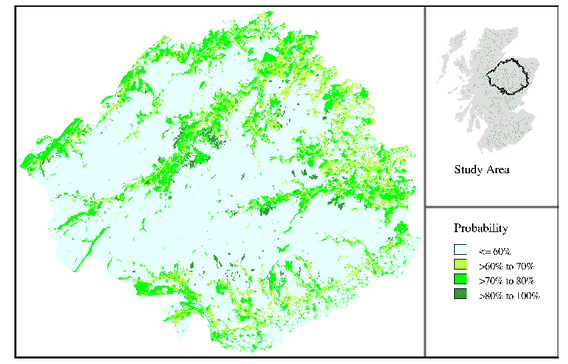
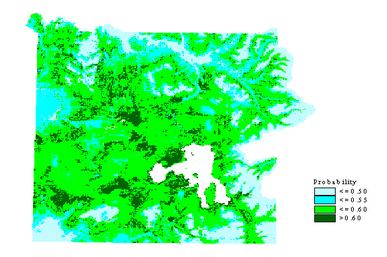
Method- a spatial model based on bayesian modelling
Scientific foundation
Principle- the method is based on calculating conditional probabilities from the relative frequency of association between the species data and attributes of the environmental data (eg climate, land cover)
Technique
Analysis- the conditional probabilities are considered to describe ecological relationships between the species and the environmental data
Generic question- how to manage species distribution data in conjunction with environmental data
Management & policy- biodiversity management
Look for an article about prediction of wildlife movement Submit a summary based on the following issues
Queries about this Session, please send them to:
*References*
- Geographic Information System Basics, 2012
J.E.Campbell & M. Shin- Fundamentals of GIS, 2017
Girmay Kindaya- GIS Applications for Water, Wastewater, and Stormwater Systems, 2005
U.M. Shamsi- Analytical and Computer Cartography, 2nd ed.
Keith C. Claike- Geographic Information Systems: The Microcomputer and Modern Cartography, 1st ed.
Fraser Taylor
Courtesy of Open School